Long Tail Point Light
Lighthouse
44°35′45″N 87°59′01″W / 44.5959°N 87.9835°W / 44.5959; -87.9835[1]Wood frame (second and third)
Square house with lantern on roof (second and third)
1859 (second)
1899 (third)[2]
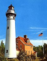
The Long Tail Point Light, also known as the Tail Point Light, was a lighthouse in Green Bay, Wisconsin, USA. Long abandoned but still standing, it was succeeded by two further structures, both since destroyed.
History
Long Tail Point is a sand bar lying at the southern end of the bay; as it lies adjacent to the channel into the city of Green Bay, a lighthouse was constructed in 1848. The structure was built from fieldstone collected at Bay Settlement on the opposite shore,[3] and was originally lit with an array of oil lamps.[2] These lamps were replaced with a Fresnel lens in the 1850s,[2] but soon the light was surrounded by water, and it was abandoned in 1859 in favor of a new house a short distance to the north.[2] The new lighthouse was an integral frame dwelling with the old lantern placed on its roof; it employed a fourth order Fresnel lens.[3] In 1899 the light's distance from the newly dredged channel prompted the construction of a third light, this time on a concrete pier resting on a wooden crib offshore;[2] the fog bell was moved to the Sand Point Light in Michigan.[4] This new crib house was much smaller than the second house, and the keepers continued to live in the latter until automation of the light in 1936.[2] A storm in 1973 washed this structure away and it was replaced by a skeleton tower.[2]
The second house was sold to a private interest on the understanding that it would be moved; however, during the attempted relocation, the structure fell through the ice and was destroyed.[5] The defunct first tower was given away in 1870, to be torn down.[2] The tower's massive stone walls, however, defeated the new owner's attempts to destroy it, and the truncated tower still stands on the sandy spit.[2][3]
Diagram of the light's location on the sand bar

References
- ^ "Long Tail Point, WI". LighthouseFriends. Retrieved 2011-01-07.
- ^ a b c d e f g h i j k "Historic Light Station Information and Photography: Wisconsin". United States Coast Guard Historian's Office. Archived from the original on 2017-05-01.
- ^ a b c Wardius, Ken; Wardius, Barb (2003). Wisconsin Lighthouses: A Photographic & Historical Guide. Black Earth, Wisconsin: Prairie Oak Press. p. 48. ISBN 9781879483606. Retrieved 2011-01-07.
- ^ "Sand Point Lighthouse". Terry Pepper. Retrieved 2011-01-07.
- ^ Harrison, Tim; Jones, Ray (2000). Lost Lighthouses: Stories and Images of America's Vanished Lighthouses. Guilford, Connecticut: Globe Pequot Press. pp. 158–159. ISBN 9780762704439. Retrieved 2011-01-07.
External links
- Ruins of the first light from LighthouseFriends
- Photograph of the second light from the Wisconsin Historical Society
- v
- t
- e
Lighthouses of Wisconsin
- Ashland Harbor Breakwater
- Chequamegon Point
- Devils Island
- Gull Island
- La Pointe
- Michigan Island
- Outer Island
- Raspberry Island
- Sand Island
- Wisconsin Point
- Algoma
- Baileys Harbor
- Baileys Harbor Range
- Cana Island
- Chambers Island
- Dunlap Reef Range
- Eagle Bluff
- Grassy Island Range
- Green Bay Harbor Entrance
- Green island
- Kenosha
- Kenosha North Pier
- Kevich
- Kewaunee Pierhead
- Long Tail
- Manitowoc Breakwater
- Milwaukee Breakwater
- Milwaukee Pierhead
- North Point
- Peshtigo Reef
- Pilot Island
- Plum Island Range
- Port Washington
- Port Washington Breakwater
- Pottawatomie
- Racine Harbor
- Racine North Breakwater
- Racine Reef
- Rawley Point
- Sheboygan
- Sherwood Point
- Sturgeon Bay Canal
- Sturgeon Bay Canal North Pierhead
- Two Rivers
- Wind Point
- Dunlap Reef Range Front
- Manitowoc Main
- Manitowoc North Pierhead
- Plum Island Range Front
- Racine North Pierhead
| Authority control databases: Geographic |
|
|---|


