Kevich Light
Lighthouse
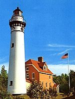
43°19′23.7″N 87°53′18.5″W / 43.323250°N 87.888472°W / 43.323250; -87.888472[1]The Kevich Light is a lighthouse located in the town of Grafton, Wisconsin.
This lighthouse was built privately by a person who has a general interest in lighthouses. It is built on the former site of the unincorporated community of Ulao, Wisconsin. It is listed on the USCG navigation maps as a private light. In 1990 it was officially registered as a United States Coast Guard Class II Private Aid Light. It is listed as light no. 20765. The light sits on a bluff and is 120 feet (37 m) above the lake level, making it the second highest light on Lake Michigan. Its 1,000 and 400 watt bulbs are surrounded by a rotating shield, resulting in four seconds of light, and then four seconds of darkness. Kevich Light is believed to be one of the last few privately owned lights in the entire United States.[2][3]
Notes
- ^ Light List, Volume VII, Great Lakes (PDF). Light List. United States Coast Guard. 2014.
- ^ Kevich Light
- ^ Kevich Light Archived 2008-09-07 at the Wayback Machine
Further reading
- Havighurst, Walter (1943) The Long Ships Passing: The Story of the Great Lakes, Macmillan Publishers.
- Oleszewski, Wes, Great Lakes Lighthouses, American and Canadian: A Comprehensive Directory/Guide to Great Lakes Lighthouses, (Gwinn, Michigan: Avery Color Studios, Inc., 1998) ISBN 0-932212-98-0.
- Pepper, Terry. "Seeing the Light: Lighthouses on the western Great Lakes". Archived from the original on 2008-01-30.
- Sapulski, Wayne S., (2001) Lighthouses of Lake Michigan: Past and Present (Paperback) (Fowlerville: Wilderness Adventure Books) ISBN 0-923568-47-6; ISBN 978-0-923568-47-4.
- Wright, Larry and Wright, Patricia, Great Lakes Lighthouses Encyclopedia Hardback (Erin: Boston Mills Press, 2006) ISBN 1-55046-399-3.
External links
- Rowlett, Russ. "Lighthouses of the United States: Eastern Wisconsin". The Lighthouse Directory. University of North Carolina at Chapel Hill.
- "Historic Light Station Information and Photography: Wisconsin". United States Coast Guard Historian's Office. Archived from the original on 2017-05-01.
- v
- t
- e
Lighthouses of Wisconsin
- Ashland Harbor Breakwater
- Chequamegon Point
- Devils Island
- Gull Island
- La Pointe
- Michigan Island
- Outer Island
- Raspberry Island
- Sand Island
- Wisconsin Point
- Algoma
- Baileys Harbor
- Baileys Harbor Range
- Cana Island
- Chambers Island
- Dunlap Reef Range
- Eagle Bluff
- Grassy Island Range
- Green Bay Harbor Entrance
- Green island
- Kenosha
- Kenosha North Pier
- Kevich
- Kewaunee Pierhead
- Long Tail
- Manitowoc Breakwater
- Milwaukee Breakwater
- Milwaukee Pierhead
- North Point
- Peshtigo Reef
- Pilot Island
- Plum Island Range
- Port Washington
- Port Washington Breakwater
- Pottawatomie
- Racine Harbor
- Racine North Breakwater
- Racine Reef
- Rawley Point
- Sheboygan
- Sherwood Point
- Sturgeon Bay Canal
- Sturgeon Bay Canal North Pierhead
- Two Rivers
- Wind Point
- Dunlap Reef Range Front
- Manitowoc Main
- Manitowoc North Pierhead
- Plum Island Range Front
- Racine North Pierhead
| Authority control databases: Geographic |
|
|---|
 | This Wisconsin-related article is a stub. You can help Wikipedia by expanding it. |
- v
- t
- e
This article relating to a United States lighthouse is a stub. You can help Wikipedia by expanding it. |
- v
- t
- e


