Hounslow (borough)
Borough van Londen  | |||
|---|---|---|---|
 | |||
| Situering | |||
| Land | Engeland | ||
| County | Outer London | ||
| Regio | London | ||
| Coördinaten | 51°28'25"NB, 0°21'56"WL | ||
| Algemeen | |||
| Oppervlakte | 55,9780[1] km² | ||
| Inwoners (2018[2]) | 270782 (4837 inw./km²) | ||
| ONS-code | E09000018 | ||
| |||

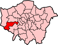
Hounslow (London Borough of Hounslow) is een Engels district of borough in de regio Groot-Londen, gelegen in het westen van de metropool. De borough telt 269.100 inwoners. De oppervlakte bedraagt 56 km². De hoofdplaats is Hounslow.
Van de bevolking is 11,5% ouder dan 65 jaar. De werkloosheid bedraagt 3,3% van de beroepsbevolking (cijfers volkstelling 2001).
Wijken in Hounslow
- Brentford
- Chiswick
- Feltham
- Gunnersbury
- Hanworth
- Heston
- Hounslow
- Isleworth
- Osterley
- Turnham Green
Bronnen, noten en/of referenties
|


