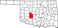
Caddo County
County in de Verenigde Staten  | |||
|---|---|---|---|
 | |||
| Situering | |||
| Staat | Oklahoma | ||
| Tijdzone | Central Standard Time (UTC−6) | ||
| Coördinaten | 35°10'48"NB, 98°22'48"WL | ||
| Algemeen | |||
| Oppervlakte | 3.342 km² | ||
| - land | 3.311 km² | ||
| - water | 31 km² | ||
| Inwoners (2000) | 30,150 (0 inw./km²) | ||
| Overig | |||
| Zetel | Anadarko | ||
| FIPS-code | 40015 | ||
| Opgericht | 1901 | ||
| Foto's | |||
 Bevolkingspiramide Caddo County | |||
| Statistieken volkstelling Caddo County | |||
| |||

Caddo County is een van de 77 county's in de Amerikaanse staat Oklahoma.
De county heeft een landoppervlakte van 3.311 km² en telt 30.150 inwoners (volkstelling 2000). De hoofdplaats is Anadarko.
Adair County · Alfalfa County · Atoka County · Beaver County · Beckham County · Blaine County · Bryan County · Caddo County · Canadian County · Carter County · Cherokee County · Choctaw County · Cimarron County · Cleveland County · Coal County · Comanche County · Cotton County · Craig County · Creek County · Custer County · Delaware County · Dewey County · Ellis County · Garfield County · Garvin County · Grady County · Grant County · Greer County · Harmon County · Harper County · Haskell County · Hughes County · Jackson County · Jefferson County · Johnston County · Kay County · Kingfisher County · Kiowa County · Latimer County · Le Flore County · Lincoln County · Logan County · Love County · Major County · Marshall County · Mayes County · McClain County · McCurtain County · McIntosh County · Murray County · Muskogee County · Noble County · Nowata County · Okfuskee County · Oklahoma County · Okmulgee County · Osage County · Ottawa County · Pawnee County · Payne County · Pittsburg County · Pontotoc County · Pottawatomie County · Pushmataha County · Roger Mills County · Rogers County · Seminole County · Sequoyah County · Stephens County · Texas County · Tillman County · Tulsa County · Wagoner County · Washington County · Washita County · Woods County · Woodward County


