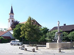
Ampfing

Cet article est une ébauche concernant une localité allemande.
Vous pouvez partager vos connaissances en l’améliorant (comment ?) selon les recommandations des projets correspondants.
| Ampfing | |||
 | |||
 Armoiries | |||
| Administration | |||
|---|---|---|---|
| Pays |  Allemagne Allemagne | ||
| Land |  Bavière Bavière | ||
| District (Regierungsbezirk) | Haute-Bavière | ||
| Arrondissement (Landkreis) | Mühldorf am Inn | ||
| Nombre de quartiers (Ortsteile) | 63 | ||
| Bourgmestre (Bürgermeister) | Ottmar Wimmer | ||
| Partis au pouvoir | CSU | ||
| Code postal | 84539 | ||
| Code communal (Gemeindeschlüssel) | 09 1 83 112 | ||
| Indicatif téléphonique | 08636 | ||
| Immatriculation | MÜ | ||
| Démographie | |||
| Population | 7 067 hab. () | ||
| Densité | 227 hab./km2 | ||
| Géographie | |||
| Coordonnées | 48° 16′ nord, 12° 25′ est | ||
| Altitude | 416 m | ||
| Superficie | 3 114 ha = 31,14 km2 | ||
| Localisation | |||
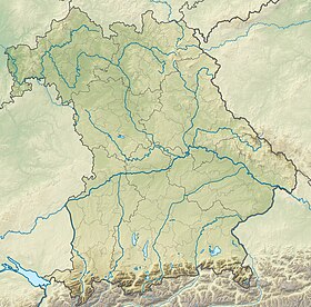
| Géolocalisation sur la carte : Allemagne
Géolocalisation sur la carte : Bavière
| |||
| Liens | |||
| Site web | www.ampfing.de | ||
modifier  | |||


Ampfing est une commune de Bavière en Allemagne, situé à 8 km de Mühldorf am Inn.
L'empereur Louis IV de Bavière y battit Frédéric d'Autriche en 1322. Le général Moreau y eut en 1800 un engagement avec les Autrichiens.
Géographie

Quartiers
|
|
|
|
Notes et références
Marie-Nicolas Bouillet et Alexis Chassang (dir.), « Ampfing » dans Dictionnaire universel d’histoire et de géographie, (lire sur Wikisource)
v · m Villes et communes de l'arrondissement de Mühldorf a.Inn | ||
|---|---|---|
|  | |
 Portail de la Bavière


