Pretty Beach, New South Wales
Suburb of Central Coast, New South Wales, Australia
| Pretty Beach Central Coast, New South Wales | |||||||||||||||
|---|---|---|---|---|---|---|---|---|---|---|---|---|---|---|---|
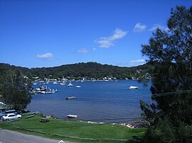 Araluen Drive, featuring the bay and wharf. Directly opposite is Wagstaffe. | |||||||||||||||
 | |||||||||||||||
| Population | 352 (2016 census)[1] | ||||||||||||||
| Postcode(s) | 2257 | ||||||||||||||
| Elevation | 2 m (7 ft) | ||||||||||||||
| Location |
| ||||||||||||||
| LGA(s) | Central Coast Council | ||||||||||||||
| Parish | Kincumber | ||||||||||||||
| State electorate(s) | Terrigal | ||||||||||||||
| Federal division(s) | Robertson | ||||||||||||||
| |||||||||||||||
Pretty Beach is a south-eastern suburb of the Central Coast region of New South Wales, Australia on the Bouddi Peninsula. It is part of the Central Coast Council local government area.
The beach itself does not face the sea directly but is part of Brisbane Water, making it a safe place for both children and the mooring of boats. Pretty Beach is surrounded by the Bouddi National Park. The main institution in the area is the Pretty Beach Public school, established in 1928, which services the greater Bouddi Peninsula community. The school had a major overhaul between 2007 and 2009 and now is entirely new. In 2010 a new community pre-school was opened immediately behind the school.
In October 2006 a 'revamped' boat ramp with floating pontoon was opened to the public that allows small and mid-sized trailer-launched boats to access Brisbane Water and beyond.
The population of the suburb recorded at the 2016 census was 352; an increase from the 249 recorded in 2006.
References
- ^ Australian Bureau of Statistics (27 June 2017). "Pretty Beach (Central Coast – NSW)". 2016 Census QuickStats. Retrieved 30 November 2017.

33°31′41″S 151°20′49″E / 33.528°S 151.347°E / -33.528; 151.347
- v
- t
- e
Suburbs of the Central Coast, New South Wales
and localities
- Alison
- Avoca Beach
- Bar Point
- Bateau Bay
- Bensville
- Berkeley Vale
- Blackwall
- Blue Bay
- Blue Haven
- Booker Bay
- Bouddi
- Box Head
- Budgewoi
- Budgewoi Peninsula
- Buff Point
- Bushells Ridge
- Calga
- Canton Beach
- Cedar Brush Creek
- Central Mangrove
- Chain Valley Bay
- Charmhaven
- Cheero Point
- Chittaway Bay
- Chittaway Point
- Cogra Bay
- Colongra
- Copacabana
- Crangan Bay
- Daleys Point
- Davistown
- Dooralong
- Doyalson
- Doyalson North
- Durren Durren
- East Gosford
- Empire Bay
- Erina
- Erina Heights
- Ettalong Beach
- Forresters Beach
- Fountaindale
- Glenning Valley
- Glenworth Valley
- Gorokan
- Gosford
- Green Point
- Greengrove
- Gunderman
- Gwandalan
- Halekulani
- Halloran
- Hamlyn Terrace
- Hardys Bay
- Holgate
- Horsfield Bay
- Jilliby
- Kangy Angy
- Kanwal
- Kariong
- Kiar
- Killarney Vale
- Killcare
- Killcare Heights
- Kincumber
- Kincumber South
- Kingfisher Shores
- Koolewong
- Kulnura
- Lake Haven
- Lake Munmorah
- Lemon Tree
- Lisarow
- Little Jilliby
- Little Wobby
- Long Jetty
- Lower Mangrove
- MacMasters Beach
- Magenta
- Mangrove Creek
- Mangrove Mountain
- Mannering Park
- Mardi
- Marlow
- Matcham
- Moonee
- Mooney Mooney
- Mooney Mooney Creek
- Mount Elliot
- Mount White
- Narara
- Niagara Park
- Norah Head
- Noraville
- North Avoca
- North Gosford
- Ourimbah
- Palm Grove
- Palmdale
- Patonga
- Pearl Beach
- Peats Ridge
- Phegans Bay
- Picketts Valley
- Point Clare
- Point Frederick
- Pretty Beach
- Ravensdale
- Rocky Point
- San Remo
- Saratoga
- Shelly Beach
- Somersby
- Spencer
- Springfield
- St Huberts Island
- Summerland Point
- Tacoma
- Tacoma South
- Tascott
- Ten Mile Hollow
- Terrigal
- The Entrance
- The Entrance North
- Toowoon Bay
- Toukley
- Tuggerah
- Tuggerawong
- Tumbi Umbi
- Umina Beach
- Upper Mangrove
- Wadalba
- Wagstaffe
- Wallarah
- Wamberal
- Warnervale
- Watanobbi
- Wendoree Park
- West Gosford
- Wisemans Ferry
- Wondabyne
- Woongarrah
- Woy Woy
- Woy Woy Bay
- Wyee
- Wyoming
- Wyong
- Wyong Creek
- Wyongah
- Yarramalong
- Yattalunga
other waterways
points of interest
 | This Central Coast geography article is a stub. You can help Wikipedia by expanding it. |
- v
- t
- e


