National Register of Historic Places listings in Pend Oreille County, Washington

This list presents the full set of buildings, structures, objects, sites, or districts designated on the National Register of Historic Places in Pend Oreille County, Washington, and offers brief descriptive information about each of them. The National Register recognizes places of national, state, or local historic significance across the United States.[1] Out of over 90,000 National Register sites nationwide,[2] Washington is home to approximately 1,500,[3] and 9 of those are found in Pend Oreille County.
This National Park Service list is complete through NPS recent listings posted June 14, 2024.[4]
Current listings
| [5] | Name on the Register | Image | Date listed[6] | Location | City or town | Description |
|---|---|---|---|---|---|---|
| 1 | Boundary Hydroelectric Project |  | May 1, 2018 (#100002394) | 1198 Boundary Dam Access Rd. 48°59′14″N 117°20′59″W / 48.9871°N 117.3496°W / 48.9871; -117.3496 (Boundary Hydroelectric Project) | Metaline vicinity | |
| 2 | Idaho and Wash. Northern RR Bridge |  | July 16, 1982 (#82004270) | Spans Pend Oreille River, off WA 31 48°46′50″N 117°24′33″W / 48.780556°N 117.409167°W / 48.780556; -117.409167 (Idaho and Wash. Northern RR Bridge) | Metaline Falls | Historic Bridges and Tunnels in Washington TR |
| 3 | Lewis P. Larson House |  | March 26, 1979 (#79002549) | 5th and Pend Oreille Blvd. 48°51′48″N 117°22′23″W / 48.863333°N 117.373056°W / 48.863333; -117.373056 (Lewis P. Larson House) | Metaline Falls | |
| 4 | Metaline Falls School |  | September 8, 1988 (#88001518) | 302 Park 48°51′40″N 117°22′26″W / 48.861111°N 117.373889°W / 48.861111; -117.373889 (Metaline Falls School) | Metaline Falls | |
| 5 | Pend Oreille County Courthouse |  | December 24, 2013 (#13000997) | 625 W. 4th St. 48°10′41″N 117°02′53″W / 48.177952°N 117.04805°W / 48.177952; -117.04805 (Pend Oreille County Courthouse) | Newport | |
| 6 | Pend Oreille Mines and Metals Building |  | August 29, 1997 (#97001081) | 103 S. Grandview St. 48°51′44″N 117°22′18″W / 48.862222°N 117.371667°W / 48.862222; -117.371667 (Pend Oreille Mines and Metals Building) | Metaline Falls | |
| 7 | Dr. John and Viola Phillips House and Office | 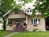 | January 3, 2006 (#05001501) | S. 337 Spokane Ave. 48°10′42″N 117°02′45″W / 48.178233°N 117.045901°W / 48.178233; -117.045901 (Dr. John and Viola Phillips House and Office) | Newport | |
| 8 | United States Border Station |  | January 31, 1997 (#96001634) | Roughly bounded by WA 31 and the U.S.-Canada border, Colville National Forest 48°59′58″N 117°18′00″W / 48.999444°N 117.3°W / 48.999444; -117.3 (United States Border Station) | Metaline Falls | |
| 9 | Washington Hotel |  | March 26, 1979 (#79002550) | 5th and Washington St. 48°51′44″N 117°22′08″W / 48.862222°N 117.368889°W / 48.862222; -117.368889 (Washington Hotel) | Metaline Falls |
See also
- National Register of Historic Places listings in Washington state
- Listings in neighboring counties: Bonner, Boundary, Spokane, Stevens
- Historic preservation
- History of Washington (state)
- Index of Washington (state)-related articles
References
- ^ Andrus, Patrick W.; Shrimpton, Rebecca H.; et al. (2002). "How to Apply the National Register Criteria for Evaluation". National Register Bulletin. National Park Service, U.S. Department of the Interior. Retrieved June 20, 2014.
- ^ National Park Service. "National Register of Historic Places Program: Research". Retrieved January 28, 2015.
- ^ Department of Archaeology and Historic Preservation. "Washington Information System for Architectural and Archaeological Records Data (WISAARD)". Retrieved February 14, 2015.
- ^ National Park Service, United States Department of the Interior, "National Register of Historic Places: Weekly List Actions", retrieved June 14, 2024.
- ^ Numbers represent an alphabetical ordering by significant words. Various colorings, defined here, differentiate National Historic Landmarks and historic districts from other NRHP buildings, structures, sites or objects.
- ^ The eight-digit number below each date is the number assigned to each location in the National Register Information System database, which can be viewed by clicking the number.
External links
Map all coordinates using OpenStreetMap
Download coordinates as:
- KML
- GPX (all coordinates)
- GPX (primary coordinates)
- GPX (secondary coordinates)
- Washington Department of Archaeology and Historic Preservation, Historic Register program
- National Park Service, National Register of Historic Places site
 Media related to National Register of Historic Places in Pend Oreille County, Washington at Wikimedia Commons
- v
- t
- e
National Register of Historic Places listings in Washington (state)
by county
- Adams
- Asotin
- Benton
- Chelan
- Clallam
- Clark
- Columbia
- Cowlitz
- Douglas
- Ferry
- Franklin
- Garfield
- Grant
- Grays Harbor
- Island
- Jefferson
- King
- Kitsap
- Kittitas
- Lewis
- Lincoln
- Mason
- Okanogan
- Pacific
- Pend Oreille
- Pierce
- San Juan
- Skagit
- Skamania
- Snohomish
- Spokane
- Stevens
- Thurston
- Wahkiakum
- Walla Walla
- Whatcom
- Whitman
- Yakima

- National Historic Landmarks
- Bridges and Tunnels
| |
|---|---|
| Topics | |
| Lists by state |
|
| Lists by insular areas | |
| Lists by associated state | |
| Other areas | |
| Related | |
| |


