Mount Hilgard
Mountain in California, United States


Mount Hilgard
Location in California
Show map of California
Mount Hilgard
Mount Hilgard (the United States)
Show map of the United StatesMount Hilgard is a 13,361-foot-elevation (4,072 meter) mountain summit located west of the crest of the Sierra Nevada mountain range in Fresno County of northern California, United States.[3] It is situated in the John Muir Wilderness on land managed by Sierra National Forest, approximately eight miles east-southeast of Lake Thomas A Edison, and immediately above the west end of Lake Italy. The nearest higher neighbor is Mount Gabb, 1.75 miles (2.82 km) to the northeast, and Recess Peak is 2.2 miles (3.5 km) to the northwest.[1] The John Muir Trail follows Bear Creek to the west of this remote peak, providing an approach. Mt. Hilgard ranks as the 82nd highest summit in California.[2]
History
This mountain was named by Sierra Club explorer Theodore Solomons for Eugene W. Hilgard (1833–1916), a professor at the University of California, Berkeley, and considered as the father of modern soil science in the United States.[5] The name was suggested to Solomons in 1895 by Ernest C. Bonner, who was one of Hilgard's former students.[5] The Hilgard name may have been initially meant for the current Recess Peak, according to Solomon's account.[5] The first ascent of the summit was made July 10, 1905, by Charles F. Urquhart, USGS topographer.[6]
Climate
According to the Köppen climate classification system, Mount Hilgard is located in an alpine climate zone.[7] Most weather fronts originate in the Pacific Ocean, and travel east toward the Sierra Nevada mountains. As fronts approach, they are forced upward by the peaks, causing them to drop their moisture in the form of rain or snowfall onto the range (orographic lift). Precipitation runoff from this mountain drains into the San Joaquin River watershed.
See also
Gallery
-
 Marie Lake with Mount Hilgard in upper right corner. Recess Peak left of center.
 -
 Mount Hilgard, west aspect
 -
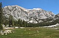
 Lake Italy with Mt. Hilgard, right


References
- ^ a b c d "Mount Hilgard, California". Peakbagger.com. Retrieved 2021-05-03.
- ^ a b c d "Hilgard, Mount - 13,361' CA". listsofjohn.com. Retrieved 2021-05-03.
- ^ a b "Mount Hilgard". Geographic Names Information System. United States Geological Survey, United States Department of the Interior. Retrieved 2021-05-03.
- ^ Hervey Voge, James W. Koontz, II, and George Bloom, Climber’s Guide to the High Sierra (1954)
- ^ a b c Francis P. Farquhar, Place Names of the High Sierra (1926)
- ^ R. J. Secor, The High Sierra Peaks, Passes, Trails, 2009, Third Edition, Mountaineers Books, ISBN 9781594857386.
- ^ Peel, M. C.; Finlayson, B. L.; McMahon, T. A. (2007). "Updated world map of the Köppen−Geiger climate classification". Hydrol. Earth Syst. Sci. 11. ISSN 1027-5606.
External links
 Mountains portal

- Weather forecast: Mount Hilgard
- v
- t
- e
- Abbot
- Agassiz
- Baldwin
- Baxter
- Bloody
- Cirque
- Crocker
- Dade
- Four Gables
- Goodale
- Graveyard
- Herlihy
- Hilgard
- Hopkins
- Humphreys
- Huntington
- Hutton
- Izaak Walton
- Julius Caesar
- Kearsarge
- Laurel
- Middle Palisade
- Mills
- Morgan
- Morrison
- Muir
- Norman Clyde
- North Palisade
- Palisade Crest
- Pilot Knob
- Red and White
- Red Slate
- Sawmill Point
- Seven Gables
- Sill
- Split
- Stanford
- Starr
- Temple Crag
- Thunderbolt
- Tom
- Tyndall
- University
- Whitney
- Williamson
- Bishop Creek
- North Fork Kings River
- Morgan Creek
- Rock Creek
- South Fork San Joaquin River
- Dingleberry
- Disappointment
- Hell for Sure
- Loch Leven
- Lone Indian
- Mills
- Nüümü Hu Hupi
- Pee Wee
- Virginia


