Jangchungdan Park
Park in Seoul, South Korea
| Jangchungdan Park | |
|---|---|
 A waterfall in the park (2012) | |
 | |
| Location | 261, Dongho-ro, Jung District, Seoul[1] |
| Area | 297 square kilometres (29,700 ha) |
| Established | 1919 |
| Korean name | |
| Hangul | 장충단 공원 |
| Hanja | 奬忠壇公園 |
| Revised Romanization | Jangchungdan Gongwon |
| McCune–Reischauer | Changch'ungdan Kongwŏn |
Jangchungdan Park (Korean: 장충단 공원) is a park located in Jung District, Seoul, South Korea. It is to the northeast of the mountain Namsan.[1][2]
It contains the historic Dangchungdan Shrine [ko], which was built by Emperor Gojong in 1900 to memorialize Empress Myeongseong. The park has a children's baseball field, a tennis court, and a swimming pool. It is popular for walks and for exercise. It has a pine tree forest, with walking trails through it.[2]
History
After the 1895 assassination of Empress Myeongseong, her husband Emperor Gojong built the Jangchungdan Shrine as a memorial to her in November 1900 in this area.[1][2] Around the time, the area was known just as "Jangchungdan".[2]
Japanese colonial period
It became a park in 1919,[1] during the Japanese colonial period. After the 1932 January 28 incident (a conflict between Japan and China), a statue was erected dedicated to Japanese soldiers who died during it. The statue was quickly torn down just after Korea was liberated in 1945.[2]
Post-liberation
The shrine was destroyed during the Korean War,[1] although it was eventually rebuilt.[2]
In 1959, the historic bridge Supyogyo [ko], which had stood over the stream Cheonggyecheon since 1420, was dismantled and moved to this park. A device used to measure the water level (수표; supyo) was also moved to the park. Both have since been designated Tangible Cultural Heritages of Seoul (No. 18 and 838 respectively).[3]
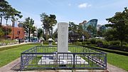
In 1964, a bronze statue of Yi Tjoune was erected in the park, and a statue of Yujeong in 1968. The rebuilt monument was designated a Tangible Cultural Heritage of Seoul in 1969.[2]
On September 22, 1984, the park, which had an area of 418,000 square metres (4,500,000 sq ft) since 1940, had a portion of it merged into Namsan Park. Its new area was 297,000 m2 (3,200,000 sq ft).[1][2]
There are now a number of other monuments in the park that commemorate the March 1st Movement, the Korean independence movement, independence activist Yu Gwan-sun and Buddhist reformer Han Yong-un.[1][2]
Between February and April 2022, the Seoul Museum of History ran an exhibition about the history of the park.[4]
Gallery
-
 The Jangchungdan Shrine, dedicated to the Empress (2016)
 -
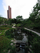 Walking paths in the park (2012)
 -
 The bridge Supyogyo, relocated from Cheonggyecheon (2008)


See also
Wikimedia Commons has media related to Jangchungdan Park.
- Hyochang Park: another historic park in Seoul with monuments to the independence movement
References
- ^ a b c d e f g "Jangchungdan Park (장충단공원)". Korea Tourism Organization. Retrieved 2023-08-22.
- ^ a b c d e f g h i "장충단공원(奬忠壇公園)". Encyclopedia of Korean Culture (in Korean). Retrieved 2023-08-22.
- ^ "Historic Sites of Cheonggyecheon Stream, Seoul (Gwangtonggyo Bridge, Supyogyo Bridge, and Ogansumun Watergate Site) - Heritage Search". Cultural Heritage Administration. Retrieved 2023-08-22.
- ^ "Jangchungdan Park: A Place of Remembrance and Rejoice | Exhibition > Lobby Exhibition | SEOUL MUSEUM OF HISTORY". museum.seoul.go.kr. Retrieved 2023-08-22.
- v
- t
- e
- Balbadak
- Choansan [ko]
- Seoul Iris Garden [ko]
- Ssangmun
- Wolcheon
- Baebongsan [ko]
- Dapsimni
- Gandaemae
- Yongdu
- Boramae [ko]
- Kachisan
- Noryangjin
- Samil Park
- Sangdo Park
- Sayuksin [ko]
- Seoul National Cemetery
- Bongsan
- Bulgwang
- Eunpyeong
- Galhyeon
- Gupabal
- Dream Forest [ko]
- Odong [ko]
- Solbat [ko]
- Cheonho [ko]
- Dongmyeong
- Gildong Ecological [ko]
- Gwangnaru Hangang [ko]
- Iljasan Park [ko]
- Myeongil
- Saemteo
- Saenmaeul
- Bongeun
- Cheongdam [ko]
- Dogok
- Dosan
- Guryongsan [ko]
- Hakdong Park
- Saemteo
- Banghwa
- Bongjesan [ko]
- Gangseo Hangang
- Guam [ko]
- Gungsan
- Maehwa [ko]
- Pheasant Hill
- Seoul Botanic [ko]
- Ujang [ko]
- Yeomchang
- Gamrocheon
- Geumcheon Athletic
- Geumcheon Waterfall
- Mansucheon
- Gwanaksan
- Nakseongdae
- Saemmal
- Children's Grand
- Ttukseom Hangang
- Gaeungsan [ko]
- Gocheok
- Onsu
- Pureun Arboretum
- Dongdaemun History & Culture
- Hullyeonwon [ko]
- Jangchungdan
- Namsan
- Seoullo 7017
- Sohn Kee-chung
- Bonghwasan [ko]
- Jungnang Camping Forest [ko]
- Manguri
- Saemteo
- Yongma
- Yongma Waterfall [ko]
- Gyeongui Line Forest [ko]
- Hyochang
- Mangwon Hangang Park
- Nanji Hangang [ko]
- Oil Tank Culture
- Sangam
- Yanghwajin Foreign Missionary Cemetery
- Wau
- World Cup
- Banpo Hangang [ko]
- Banpo Sports Complex
- Guryongsan
- Jamwon Hangang
- Maljukgeori
- Seoripul
- Maeheon Citizen's Forest
- Culture and Arts
- Yeomgok
- Ansan
- Baengnyeonsan
- Bukhansan
- Gungdong
- Seodaemun Independence
- Cheongryang
- Gaeunsan
- Odong Neighborhood
- Odong [ko]
- Seongbuk
- Dalmaji
- Eungbong
- Eungbong Rock Climbing [ko]
- Eungbongsan
- Geumho
- Seongsu
- Seoul Forest
- Asia
- Cheonma
- Jamsil Hangang
- Jangji
- Munjeong
- Ogeum
- Olympic
- Seokchon Lake
- Galsan
- Gyenam
- Paris
- West Seoul Lake
- Yongwangsan
- Yangcheon
- Ankara
- Mullae
- Jungmaru
- Seonyudo
- Yanghwa Hangang
- Yeungdeungpo
- Yeouido Hangang
- Yeouido
- Yeouido Saetgang Ecological [ko]
- Eungbong
- Nodeul Farm
- Hyochang
- Ichon Hangang
- Yongsan Family
37°33′28″N 127°00′16″E / 37.55778°N 127.00444°E / 37.55778; 127.00444


