Far Hills station
NJ Transit rail station
Far Hills | |||||||||||||
|---|---|---|---|---|---|---|---|---|---|---|---|---|---|
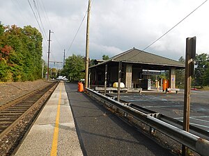 Far Hills station in September 2020. | |||||||||||||
| General information | |||||||||||||
| Location | 57 Route 202 (at junction with CR 512) Far Hills, New Jersey 07931 | ||||||||||||
| Owned by | NJ Transit | ||||||||||||
| Platforms | 1 side platform | ||||||||||||
| Tracks | 1 | ||||||||||||
| Connections |  Lakeland: 78 Lakeland: 78 | ||||||||||||
| Construction | |||||||||||||
| Parking | Yes | ||||||||||||
| Other information | |||||||||||||
| Station code | 719 (Delaware, Lackawanna and Western) [1] | ||||||||||||
| Fare zone | 17 | ||||||||||||
| History | |||||||||||||
| Opened | October 10, 1890[2][3] | ||||||||||||
| Rebuilt | June 2–December 20, 1914[4][5] | ||||||||||||
| Electrified | January 6, 1931[6] | ||||||||||||
| Key dates | |||||||||||||
| July 1, 1981 | Station agency closed[7] | ||||||||||||
| Passengers | |||||||||||||
| 2017 | 113 (average weekday)[8][9] | ||||||||||||
| Services | |||||||||||||
| |||||||||||||
| |||||||||||||
Far Hills Station | |||||||||||||
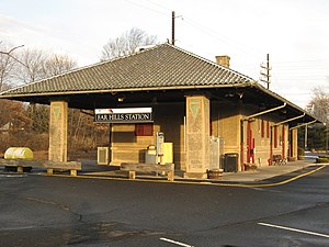 The 1914 station depot of the Delaware, Lackawanna and Western Railroad at Far Hills. | |||||||||||||
| Location | Far Hills, New Jersey | ||||||||||||
| Coordinates | 40°41′8″N 74°38′3″W / 40.68556°N 74.63417°W / 40.68556; -74.63417 | ||||||||||||
| Area | 0.8 acres (0.3 ha) | ||||||||||||
| Built | 1914 | ||||||||||||
| Architect | Simpson, L.R.[11] | ||||||||||||
| Architectural style | Renaissance | ||||||||||||
| MPS | Operating Passenger Railroad Stations TR | ||||||||||||
| NRHP reference No. | 84002789[10] | ||||||||||||
| Added to NRHP | June 22, 1984 | ||||||||||||
| |||||||||||||

Far Hills is a NJ Transit station in Far Hills, in Somerset County, New Jersey, United States located at the intersection of Route 202 and CR 512, one-half mile (0.80 km) east of Route 206.
History
The Spanish Revival-style station was built in 1914 and also includes an old freight station to the west in a similar design. The head house has been on the state and federal registers of historic places since 1984,[12] listed as part of the Operating Passenger Railroad Stations Thematic Resource.[13]
Station layout

In addition to the building with ticket office and waiting room, permitted parking is available, along with bicycle racks along the station house wall. There is one low-level concrete side platform. Near the station, there is a passing siding to allow east and westbound trains to get past each other.
The Far Hills station has a restaurant called Butler's Pantry and is part of the NJ Transit Gladstone Branch, offering service to Hoboken Terminal, and to Penn Station in Midtown Manhattan via the Kearny Connection. The station is also known as Far Hills–Bedminster because of its proximity to the town. During an earlier era, most riders would get off at the Far Hills station for the horse races at the Far Hills Steeplechase Farm.
See also
- List of New Jersey Transit stations
- National Register of Historic Places listings in Somerset County, New Jersey
References
- ^ List of Station Numbers. Delaware, Lackawanna and Western Railroad (Report). 1952. p. 2.
- ^ Stuart, Sandy (April 26, 1990). "Competing Railroads Pulled Into Peapack 100 Years Ago Last week". The Bernardsville News. p. 3. Retrieved October 4, 2017 – via Newspapers.com.

- ^ Operating Passenger Railroad Stations in New Jersey (Report). National Register of Historic Places. 1981. p. 41. Retrieved March 31, 2020.
- ^ "Whitehouse". The Plainfield Courier-News. June 6, 1914. p. 9. Retrieved March 31, 2020 – via Newspapers.com.
- ^ "New Far Hills Station Opened". The Bernardsville News. December 24, 1914. p. 8. Retrieved October 4, 2017 – via Newspapers.com.
- ^ "Bedecked Municipalities on P. & D. Branch Greet First Electric Train Run". The Plainfield Courier-News. January 7, 1931. pp. 1, 13. Retrieved January 31, 2021 – via Newspapers.com.
- ^ Jones, Daniel P. (May 14, 1981). "Two Rush-Hour Trains Cut From Gladstone Branch". The Bernardsville News. pp. 1–2. Retrieved March 16, 2019 – via Newspapers.com.
- ^ "QUARTERLY RIDERSHIP TRENDS ANALYSIS" (PDF). New Jersey Transit. Archived from the original (PDF) on April 19, 2013. Retrieved January 4, 2013.
- ^ Kiefer, Eric (February 21, 2018). "How Many Riders Use NJ Transit's Hoboken Train Station?". Hoboken Patch. Retrieved July 18, 2018.
- ^ "National Register Information System". National Register of Historic Places. National Park Service. July 9, 2010.
- ^ Richard Meyer (May 1981). "New Jersey Transit Railroad Station Survey: Far Hills Station" (PDF). National Park Service. Retrieved May 31, 2015. Photo (1978)
- ^ "Far Hills Station". Focus. National Park Service. Retrieved January 8, 2016.
- ^ Far Hills New Jersey Transit Railroad Station Survey
External links
 Media related to Far Hills (NJT station) at Wikimedia Commons
- Station from US 202 from Google Maps Street View
- v
- t
- e
- Hoboken
- Secaucus Junction
- Harmon Cove
- Rutherford
- Wesmont
- Garfield
- Plauderville
- Broadway
- Radburn
- Glen Rock–Boro Hall
- Ridgewood
- Ho-Ho-Kus
- Waldwick
- Allendale
- Ramsey
- Ramsey Route 17
- Mahwah
- Suffern
| Midtown Direct | |
|---|---|
| Hoboken |
|
- Newark Broad Street
- Roseville Avenue
- Grove Street
- East Orange
- Brick Church
- Orange
- Highland Avenue
- Mountain Station
- South Orange
- Maplewood
- Millburn
- Short Hills
- Summit
- New Providence
- Murray Hill
- Berkeley Heights
- Gillette
- Stirling
- Millington
- Lyons
- Basking Ridge
- Bernardsville
- Far Hills
- Peapack
- Gladstone
| Midtown Direct | |
|---|---|
| Hoboken |
| Boonton Line |
|
|---|
- Harrison
- Newark Broad Street
- Roseville Avenue
- Ampere
- Watsessing Avenue
- Bloomfield
- Glen Ridge
- Bay Street
- Walnut Street
- Watchung Avenue
- Upper Montclair
- Mountain Avenue
- Montclair Heights
- Montclair State University
- Great Notch
- Little Falls
- Wayne Route 23
- Mountain View
- Lincoln Park
- Towaco
- Boonton
- Mountain Lakes
- Denville
- Dover
- Mount Arlington
- Lake Hopatcong
- Netcong
- Mount Olive
- Hackettstown
| Midtown Direct | |
|---|---|
| Hoboken |
|
- Newark Broad Street
- Roseville Avenue
- Grove Street
- East Orange
- Brick Church
- Orange
- Highland Avenue
- Mountain Station
- South Orange
- Maplewood
- Millburn
- Short Hills
- Summit
- Chatham
- Madison
- Convent Station
- Morristown
- Morris Plains
- Mount Tabor
- Denville
- Dover
- Mount Arlington
- Lake Hopatcong
- Netcong
- Mount Olive
- Hackettstown
| Penn Station | |
|---|---|
| Hoboken |
- Newark Penn Station
- Newark Liberty International Airport
- North Elizabeth
- Elizabeth
- Linden
- North Rahway
- Rahway
- Avenel
- Woodbridge
- Perth Amboy
- South Amboy
- Aberdeen–Matawan
- Hazlet
- Middletown
- Red Bank
- Little Silver
- Monmouth Park
- Long Branch
- Elberon
- Allenhurst
- Asbury Park
- Bradley Beach
- Belmar
- Spring Lake
- Manasquan
- Point Pleasant Beach
- Bay Head
| Princeton Branch |
|
|---|
- Hoboken
- Secaucus Junction
- Wood-Ridge
- Teterboro
- Essex Street
- Anderson Street
- Fairmount Avenue
- New Bridge Landing
- River Edge
- Oradell
- Emerson
- Westwood
- Hillsdale
- Woodcliff Lake
- Park Ridge
- Montvale
- Pearl River
- Nanuet
- Spring Valley
| Penn Station | |
|---|---|
| Hoboken |
- Newark Penn Station
- Union
- Roselle Park
- Cranford
- Garwood
- Westfield
- Fanwood
- Netherwood
- Plainfield
- Grant Avenue
- Dunellen
- Bound Brook
- Bridgewater
- Finderne
- Somerville
- Raritan
- North Branch
- White House
- Lebanon
- Annandale
- High Bridge
Italics denote closed stations, stations under construction, and unused line segments.
Stations north of Montvale are operated by Metro-North Railroad


