Beets, Netherlands
Village in North Holland, Netherlands
Coat of arms
52°35′21″N 4°58′39″E / 52.58917°N 4.97750°E / 52.58917; 4.97750
(2021)[1]
1475[1]
Beets (Dutch pronunciation: [ˈbeːts]) is a village in the northwest Netherlands. It is a part of the municipality of Edam-Volendam, North Holland, and lies about 9 km southwest of Hoorn.
History
The village was first mentioned in 1435 as "van der Beetze", and means "low lying (often flooded in the winter) land".[3] Beets developed in the late 13th century on the southern part of the Beetskoog polder.[4]
The Dutch Reformed church is a single aisled cruciform church from the 15th century. It was restored in 1873 and 1961.[4]
Beets was home to 412 people in 1840.[5] Until 1970, Beets was a separate municipality.[6] In 2016, it became part of the municipality of Edam-Volendam.[5]
Gallery
-
 Farm in Beets
 -
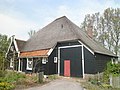 Farm in Beets


References
- ^ a b c "Kerncijfers wijken en buurten 2021". Central Bureau of Statistics. Retrieved 29 April 2022.
- ^ "Postcodetool for 1475AA". Actueel Hoogtebestand Nederland (in Dutch). Het Waterschapshuis. Retrieved 29 April 2022.
- ^ "Beets - (geografische naam)". Etymologiebank (in Dutch). Retrieved 29 April 2022.
- ^ a b Ronald Stenvert & Saskia van Ginkel-Meester (2006). "Beets" (in Dutch). Zwolle: Waanders. Retrieved 29 April 2022.
- ^ a b "Beets". Plaatsengids (in Dutch). Retrieved 29 April 2022.
- ^ Ad van der Meer and Onno Boonstra, Repertorium van Nederlandse gemeenten, KNAW, 2011.
 | This North Holland location article is a stub. You can help Wikipedia by expanding it. |
- v
- t
- e


